


Location: Harstad
Top Things to do in Harstad
The 6 Best Hiking Trails in Harstad, Northern Norway
Harstad (help·info) is the second-most populated municipality in Troms county, Norway. It is mostly located on the large island of Hinnøya. The municipal center is the town of Harstad, the most populous town in Central Hålogaland, and the third-largest in all of Northern Norway. The town was incorporated in 1904. Villages in the municipality include Elgsnes, Fauskevåg, Gausvik, Grøtavær, Kasfjord, Lundenes, Nergården and Sørvika.
Restaurants in Harstad
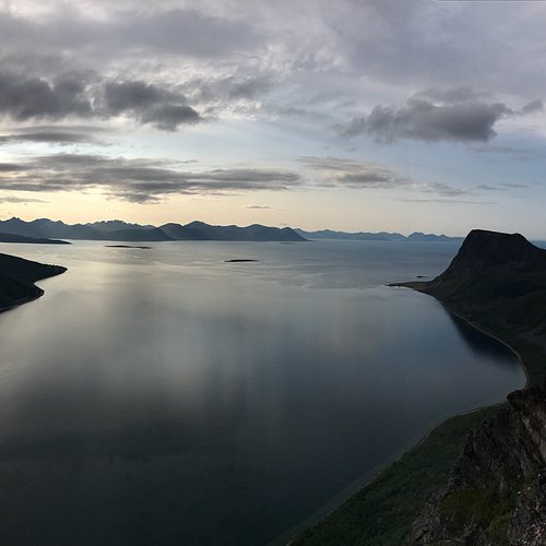
1. Mountain Hike to Saetertinden
Overall Ratings
5.0 based on 4 reviews

Distance: approx 15km there and back. Estimated time to the summit: 4 – 5 hours Suitable for: The physical fit. The last part to the top is a little demanding. Start and finish: Go south from Harstad, past Tjeldsund Bridge and towards Lodingen. Park at Sandtorg sportsground (signposted in arbogen). Necessary equipment: None, but good shoes are recommended due to rocky parts at the end. Map: Walking map of Vesteralen-Hinnoya (Statens kartverk 1:100 000) Marked trail: No. Good path. Visible peak from starting point. Drinking water: Intermittent before the final ascent to the top. Route description: Follow path/road through the gate from the football pitch. There is a road heading to arbogvatnet 258m. (Alternatively, you can follow the path on the west side of arbogelva). Continue from the lake a short distance south to the ridge, where you will find a cabin (book). From here, follow the posts to the top. Follow the same route going back. If you descend along the road on the north side of the river, make sure that you continue straight on where the paths meet on the plain close to the sportsground. If you don’t, you will end up on the north side of the river and have to follow the road all the way down to E-10 and then head south and back up again to the sportsground.
2. Gangsastoppen
Overall Ratings
4.5 based on 26 reviews

Distance: 3.5km there and back. Estimated time to the top: 30 minutes Suitable for: Most people. Start and finish: Car park in Toppenveien. Drive to the roundabout at Kanebogen Shopping Centre (3km south of Harstad city centre). Go past Shell petrol station. Turn right at the second road, Gamle Stangnesvei. From here it is signposted to the car park. Map available at the tourist office. Necessary equipment: None. Map: Walking map of Harstad (1:30 000) Marked trail: No. Good path. Drinking water: No. Route description: Good trail to the top. Rolling birch ground. There are benches and a binocular on the top. Fantastic views across the city of Harstad.
Reviewed By 336gj_rans - Harstad, Norway
If you want a great view of Harstad city just follow the marked trails up to Gansåstoppen. On the top you will find benches for a rest. Approx 30 min hike from the parking spot.
3. Mountain Hike to Musvannet
Overall Ratings
4.5 based on 18 reviews

Distance: 9km there and back. Estimated time to the top: 1 hour 15 minutes Suitable for: Most people. Good jogging trail. Start and finish: Folkeparken. Folkeparken is situated approx 5 minutes from the city centre. Drive past and at the back of the hospital and to the large car park at the end of the road. Necessary equipment: None. Map: Walking map of Harstad (1:30 000) Marked trail: Partly signposted only. Drinking water: After about 2km. Route description: Take the gravelled road straight on and past Grunnvannet. At the crossroad at end of Grunnvannet, continue straight on along the gravelled road (sloping down and a little to the left). The road is called Fjellveien. Follow the road down and then up to a crossroad, where it is signposted to Musvannet. There is a “gapahuk” (rustic shelter) with a fireplace at Musvannet.
4. Keipen

5. Mountain Hike to Hinnstein
Overall Ratings
4.0 based on 5 reviews

Distance: 6-7km there and back. Estimated time to the top: 1 – 1½ hours Suitable for: Most people – somewhat physical demanding. Tough jogging trail. Start and finish: Medkila school (also other alternatives) Medkila school is situated approx 5km south of Harstad. Turn at the sign to StatoilHydro and turn right after Skeidar furnisher shop. Continue past the school. Car park just past the nursery school. Necessary equipment: None. Map: Walking map of Harstad (1:30 000) Marked trail: No. Good path. Visible peak from starting point. Drinking water: Small brooks. Route description: Follow trail from car park. As you ascend on the left hand side of Hinnstein, you will find a path to the top. Fantastic views to the north, south and east.
6. Footsteps of the Vikings
Take a day off – travel in the footsteps of the Vikings. The journey starts at Trondenes Historical Centre, where local history – emphasising the Viking and Medieval Ages – is told through original exhibits, multi-media show, specially composed music, sights and smells. The visit on the Trondenes peninsula is concluded on the culture trail where you will be able to see remnants of boathouses previously housing vessels of the chieftain Asbjorn Selsbane. Map of the trail is available in the souvenir shop at Trondenes Historical Centre. The journey continues to Bjarkoy – in the kingdom of Tore Hund. Ole Ottesastua from 1870 is situated on top of a very large farmyard at overgard, and indications are that it may have been the home of Tore Hund himself. Open all year by contacting Sor-Troms Museum, where you will find map and further information about the culture trail on the Saga island.