


Top Things to do in Al Municipality
The 10 Best Nature & Parks in Al Municipality, Eastern Norway
Discover the best top things to do in Al Municipality, Norway including Al Skicentre, Bike Trips Torpo Opheim, Sundreberget, Tracks Bergsjo Area, Hallingdal Natur og Miljosenter, Dyna at Vestasen, Hillbilly MTB - Day Tours, Liatoppen Skicentre, Versjoen, Toviken Klevahytta Lungsdalen.
Restaurants in Al Municipality
1. Al Skicentre
Overall Ratings
4.5 based on 5 reviews
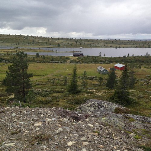
al Skicentre is situated in Votndalen, some 7 km from the centre of al. Nice family area, free-ride park and slopes for all skiers. Café, ski rental and ski school. The family and children’s section has a ski lift, a family slope and Slattajordet. The facilities enable skiers to progress to the level required for skiing right from the top of the mountain. al skicentre is most famous for the Svarteberg piste, one of Norway’s best giant slalom slopes. The national Norwegian men and women’s alpine ski teams frequently practise here. The parkarea is right beside the Svarteberg piste and contains several jump, which suits all levels of experience. There are also some rails. Every Tuesday and Thursday evening the tracks are floodlight.
2. Bike Trips Torpo Opheim
Overall Ratings
4.5 based on 2 reviews
You can start the trip in the centre of Torpo, but it's quite steep until you reach the toll road. To avoid the climb, you can start at the toll bar in Opheim. The terrain is kinder from here, and you have more opportunities to choose different roads and trips. You can choose to take the trip to Liatopppen and down the mountainside through Liagardane (it is also possible to cycle further around Votndalen) or to Breiseth. Another opportunity is to cycle pass oknin to Volelie (possibly over Syningen and down to Torpo) Possible trips: - Opheim - Liatoppen - Liagardane - Torpo - Opheim - Breiseth - Tjukketjorr - Opheim - Around Volelie
3. Sundreberget
Overall Ratings
4.0 based on 3 reviews
4 km hike in forest terrain with great view. This hike is close to the centre of al and you can see it when standing in the centre. A birds-eye view over the centre of al and Vestlia both along the hike and from the top. The hike is also called The troll path as it is it a bit magical. See tour description. Start the hike from the centre starting from Gamlevegen and onto Trolldalsvegen to the left. Follow the path by the sign Trollstigen. The hike is well marked towards the view point on Sundreberget Walking back to the centre you can either take the same path or take to the right 200 metres down the path which will lead you to ovre-alsvegen towards the crossroad by the schools. If you fancy a longer hike you just follow the path along the mountain/rock. You will pass several view points along the way with information boards telling you about geology, flora, fauna and more in the surrounding areas. Follow the path until it comes back to the viewpoint on Sundreberget. The hike can have an alternative start and end in ovre-al by the information board. Medium hike due to the steep start. You will use approx 20 - 30 min tour/return Sundreberget. If you walk the whole hike around it take about 1 1/2 hour from start and end in the centre. Parkering in the centre by the police station.
4. Tracks Bergsjo Area
Overall Ratings
4.0 based on 3 reviews
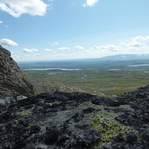
Treat yourself to fantastic experiences in one of Norways most beautiful mountain areas. Climbing Reineskarvet might be hard but the view from the top will take your breath away. The terrain is slightly hilly. On very windy days, your are advised to ski in the forest rather than the mountains. Indeed, some of the forest routes are known as ‘bad weather tracks”. There is a network of tracks from Bergsjo to Hevjanasen and al ski centre, Votndalsasen and Liatoppen ski centre and Torpo-Oppheimsasen. The route from Myrland via Bergsjo to Votndalsasen and on to Torpoasen is known as the northern Hallingdal route. The kiosk at Reine i open every day from winter holiday and until after Easter. It is toll road on the mountain road to Nysetlia. For more information regarding payment, you find this by the toll road. There is often a parking fee on the parking spots in the mountain during winter season. Maps: Reineskarvet 1:50 000 Skarvheimen 1:50 000
5. Hallingdal Natur og Miljosenter
Hallingdal Natur & Miljosenter is a private exhibition of the bird- and animal life in northern parts of Buskerud. The exhibitions are built as three dimensional dioramas and shows different situations from the nature. The exhibition consists of 7 large and 2 small dioramas that has taken 12.000 hours to build. The building of these dioramas are made by Ole-Reidar Lagrinn, who runs one of Europes leading preparation companies, Atelier Lagrinn Zoo. Prep. The background materials are gathered from the mountains for al made by the sculpturer Jan Fekjan. Groups can book showaround in the exhibition by contacting Ole-Reidar Lagrinn.
6. Dyna at Vestasen
Round trip approx 12 km long in easy mountain terrain with the top at Dyna as a highlight. Fantastic view over al from the top ! Start the hike by driving past the station to Vestlivegen from the centre of al to Bosset where you find a parking spot. Toll road. From Bosset the hike goes along a good path between Restjodnan and towards Dyna (1212 masl). You will pass Bispen on your way to the peak. Further the hike goes along the path down to Steinstolen, and from here you follow the mountain road to Fjellheim. Continue on the path from Fjellheim back to Bosset. The hike is in easy terrain on paths, mountain road and is well marked. As an alternative you can walk this round trip in the other direction, or as a shorter alternative you can only walk from Bosset to Dyna and then back again. A more detailed map: Vestasen 1:50 000
7. Hillbilly MTB - Day Tours

We are a guide and bike rental company that take you out mountainbiking on amazing trails in Hallingdal, Oslo and Sogndal, Norway. We also operate Hillbilly Bike Park. Visit our website for more information.
8. Liatoppen Skicentre
Liatoppen skicentre is located in Liagardane, 920 m.a.s.l and is an impressive biathlon- and crosscountry arena meeting international standards. At Liatoppen the season always starts early in the winter and you are sure to have snow. There is also a floodlit track for those who like an evening ski trip. The centre hosts several cross-country and biathlon races during the winter season. Every year Liatoppen is a host to then Bendit Liatoppen Biathlon festival. This biathlon festival marks the end of the winter season for biathletes of all ages. Almost 1,000 competitors ranging from young recruits to professional skiers on the Norwegian national team gather in al for two days of competition and fun. Liatoppen Fjellstove is the closest neighbour.
9. Versjoen
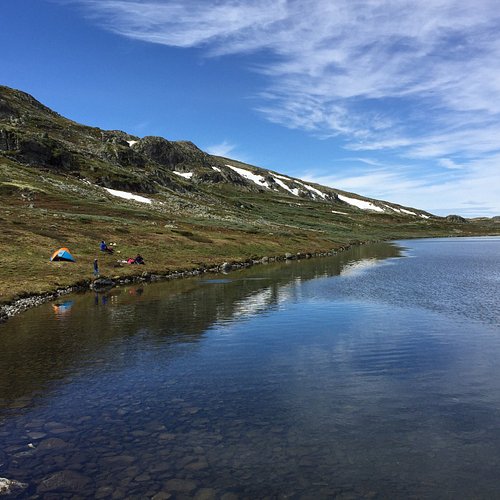
Easy hike 6 km tour/return from Vealia to Versjoen at Votndalsasen in al. You can view several mountain tops along the way, possibility for bathing and an exciting stony cabin worth a look. The hike starts at Vealia where river Eitra crosses the road. There is a parking lot by the small bridge. You get there by driving up Liagardane or Votndalen, inward the mountain past asetno, Tormodset, river Lya and Nystolen. Toll road. First part of the hike you follow a wide path along the river Eitra until the terrain flattens out. On the left side of the path towards Versjoen you see the mountain tops Syningen (1235 masl), Buhovd (1351 masl) og Svaraberget (1456 masl). The path continues in easy terrain, and you will get Kyrkjetjorni on your right side, with lake Versjoen behind you (1234 masl). Follow the path until you come to an old restored stony cabin on the left side of Kyrkjetjorni. This is also a good place to take a break. If you continue the path a bit further you will pass a newer fishing cabin before continuing towards north east and arrive a cosy sandy beach by Versjoen. During summer you try a refreshing bath here ! You can end the hike here and return the same way back. If you wish a longer hike continue the path inward along Versjoen until you pass Hjallestolen, and end up in Venebotten. Here you also find an old stony cabin. You are now at the end of Versjoen and to be able to have a round trip you must follow the path back on the oposite side of the lake. You will first pass Driftestolen and continue along the lake until you are back between Versjoen and Kyrkjetjorni. Same path back down to Vealia. When doing this trip as a round trip it is altogether 15 km and walking time approx 4 hours. Recommended map: Reineskarvet 1:50 000.
10. Toviken Klevahytta Lungsdalen
Memorable hike on the high mountains i Skarvheimen in al 1090 - 1280 masl, with powerful nature all around you. The hike is approx 13 km and you should count 4-5 hours including break. Well marked path, partly steep and somewhat challenging. Start in Toviken. Follow the path along the westside of river Mjolga. After one km walk the path turns left towards Klevaskardet (North West). At the top of Klevaskardet the path continues in slightly hilly terrain til you come to Store Klevavatnet. Then you walk along the south west side of the water towards Fodalen i somewhat stony terrain. You then arrive at Klevahytta where it is good to have a break. You will have a magnificent view towards Klevavatnet, Fodalen/ Fodalsvatnet and Systrandfossen altogether. Continue on the DNT path towards Fodalen and to Iungsdalshytta, which is a Norwegian Tourist Association cabin. During summer season you can both be served food and spend the night if you want. There is also a possibility for a lift with boat back to Toviken. From Iungsdalshytta the path follows the water back to Toviken. As an alternative you can walk this hike in the other direction. The hike can also be combined with fishing in Toviken or by Iungsdalsytta. Fishing permit needed. Arrival / parking: Take off from Highway 7 by Gullhagen (Hallingmobler) at Gullagen in al, and follow county road 244 towards Vats. Pass throught Bergsjoomradet, Djup and to Toviken. Toll road. Parking lot by river Mjolga, before the bridge just before Toviken. Recommended maps: Reineskarvet 1:50 000 or Skarvheimen 1:50 000.